Connect with us

Science

Aditya-L1: The Indian first mission to the Sun is successfully launched

Published

on

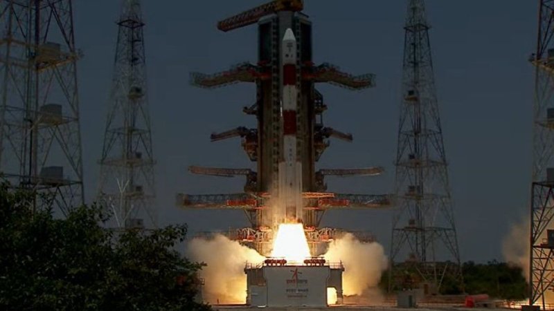
At 11:50 India time (06:20 GMT) on Saturday, Aditya-L1 launched from the launch facility at Sriharikota.

It will cover 1.5 million kilometres (932,000 miles) or 1% of the distance between the Earth and the Sun.

According to India’s space agency, the journey will take four months.

The name of India’s first space-based project to examine the largest object in the solar system comes from Surya, the Hindu sun god also known as Aditya.

L1 stands for Lagrange point 1, the precise location where the Indian spacecraft is travelling between the Sun and Earth.

A Lagrange point, according to the European Space Agency, is a location where the gravitational pull of two enormous objects, such as the Sun and the Earth, cancel each other out and allow a spacecraft to “hover.”

Aditya-L1 will be able to orbit the Sun at the same speed as the Earth once it reaches its “parking spot” This implies that the satellite will run on very little fuel.

A few thousand people gathered to watch the launch on Saturday morning at the viewing gallery set up by the Indian Space Research Agency (Isro) close to the launch site.

Additionally, it was live-broadcast on national television, where the pundits referred to it as a “magnificent” launch. The launch was successful, according to Isro experts, and its “performance is normal.”

Before heading towards L1, the spacecraft will now make many orbits of the planet.

Aditya-L1 will be able to observe the Sun continuously from this vantage point, even when it is obscured by an eclipse, and conduct research.

Isro has not specified the cost of the mission, however estimates in the Indian press estimate it to be 3.78 billion rupees ($46 million; £36 million).

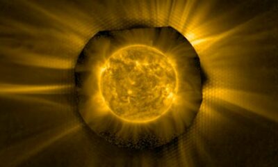
According to Isro, the orbiter is equipped with seven scientific tools to examine and analyse the solar corona, which is the sun’s outermost layer, the photosphere, which is the part of the sun that we can see from Earth, and the chromosphere, which is a thin layer of plasma between the photosphere and the corona.

The research will aid in the understanding of solar activity, including solar wind and solar flares, and their immediate impact on Earth and near-space weather.

Mylswamy Annadurai, a former scientist of Isro, claims that the Sun constantly affects Earth’s weather through radiation, heat, the movement of particles, and magnetic fields. He claims that it also affects the space weather at the same time.

“Space weather plays a role in how effectively the satellites function. Solar winds or storms can affect the electronics on satellites, even knock down power grids. But there are gaps in our knowledge of space weather,” Mr Annadurai told the BBC.

India has more than 50 satellites in orbit, and they offer the nation a variety of vital services including communication channels, weather information, and assistance in forecasting pest infestations, droughts, and imminent disasters. Nearly 7,800 of the 10,290 satellites still in Earth’s orbit are active, according to the United Nations Office for Outer Space Affairs (UNOOSA).

According to Mr. Annadurai, Aditya will aid in our understanding of the star that is essential to our survival and even provide us with a warning.

We can shift our satellites out of harm’s way if we are aware of the Sun’s activities, such as solar wind or an impending solar eruption, a few days in advance. This will prolong the life of our satellites in orbit.

The mission, he continues, will primarily contribute to advancing our knowledge of the Sun, the 4.5 billion year old star that is the centre of our solar system.

Just a few days prior to its solar mission, India had successfully landed the first probe in history close to the lunar south pole.

With that, India joined the United States, the former Soviet Union, and China as the only other nations to successfully complete a soft landing on the moon.

India will join the exclusive group of nations that are already researching the Sun if Aditya-L1 is a success.

Japan launched the first mission in 1981 to investigate solar flares, and since the 1990s, both the US space agency Nasa and the European Space Agency (ESA) have been keeping an eye on the Sun.

A Solar Orbiter that was jointly launched by NASA and ESA in February 2020 is studying the Sun up close and gathering data that, according to scientists, will help them understand what motivates its dynamic activity.

And in 2021, the Parker Solar Probe, one of NASA’s newest spacecraft, made history by being the first to go through the corona, the Sun’s outer atmosphere.

Science

AI is changing sea ice melting climate projections

Published

on

By

AI is changing sea ice melting climate projections

The tremendous melting of sea ice at the poles is one of the most urgent problems facing planet as it warms up so quickly. These delicate ecosystems, whose survival depends so heavily on floating ice, have a difficult and uncertain future.

As a result, climate scientists are using AI more and more to transform our knowledge of this vital habitat and the actions that can be taken to preserve it.

Determining the precise date at which the Arctic will become ice-free is one of the most urgent problems that must be addressed in order to develop mitigation and preservation strategies. A step toward this, according to Princeton University research scientist William Gregory, is to lower the uncertainty in climate models to produce these kinds of forecasts.

“This study was inspired by the need to improve climate model predictions of sea ice at the polar regions, as well as increase our confidence in future sea ice projections,” said Gregory.

Arctic sea ice is a major factor in the acceleration of global climate change because it cools the planet overall by reflecting solar radiation back into space. But because of climate change brought on by our reliance on gas, oil, and coal, the polar regions are warming considerably faster than the rest of the world. When the sea is too warm for ice to form, more solar radiation is absorbed by the Earth’s surface, which warms the climate even more and reduces the amount of ice that forms.

Because of this, polar sea ice is extremely important even outside of the poles. The Arctic Ocean will probably eventually have no sea ice in the summer, which will intensify global warming’s effects on the rest of the world.

AI coming to the rescue

Predictions of the atmosphere, land, sea ice, and ocean are consistently biased as a result of errors in climate models, such as missing physics and numerical approximations. Gregory and his colleagues decided to use a kind of deep learning algorithm known as a convolutional neural network for the first time in order to get around these inherent problems with sea ice models.

“We often need to approximate certain physical laws in order to save on [computational] time,” wrote the team in their study. “Therefore, we often use a process called data assimilation to combine our climate model predictions together with observations, to produce our ‘best guess’ of the climate system. The difference between best-guess-models and original predictions provides clues as to how wrong our original climate model is.”

The team aims to show a computer algorithm  “lots of examples of sea ice, atmosphere and ocean climate model predictions, and see if it can learn its own inherent sea ice errors” according to their study published in JAMES.

Gregory explained that the neural network “can predict how wrong the climate model’s sea ice conditions are, without actually needing to see any sea ice observations,” which means that once it learns the features of the observed sea ice, it can correct the model on its own.

They achieved this by using climate model-simulated variables such as sea ice velocity, salinity, and ocean temperature. In the model, each of these factors adds to the overall representation of the Earth’s climate.

“Model state variables are simply physical fields which are represented by the climate model,” explained Gregory. “For example, sea-surface temperature is a model state variable and corresponds to the temperature in the top two meters of the ocean.

“We initially selected state variables based on those which we thought a-priori are likely to have an impact on sea ice conditions within the model. We then confirmed which state variables were important by evaluating their impact on the prediction skill of the [neural network],” explained Gregory.

In this instance, the most important input variables were found to be surface temperature and sea ice concentration—much fewer than what most climate models require to replicate sea ice. In order to fix the model prediction errors, the team then trained the neural network on decades’ worth of observed sea ice maps.

An “increment” is an additional value that indicates how much the neural network was able to enhance the model simulation. It is the difference between the initial prediction made by the model without AI and the corrected model state.

A revolution in progress

Though it is still in its early stages, artificial intelligence is becoming more and more used in climate science. According to Gregory, he and his colleagues are currently investigating whether their neural network can be applied to scenarios other than sea ice.

“The results show that it is possible to use deep learning models to predict the systematic [model biases] from data assimilation increments, and […] reduce sea ice bias and improve model simulations,” said Feiyu Lu, project scientist at UCAR and NOAA/GFDL, and involved in the same project that funded this study.

“Since this is a very new area of active research, there are definitely some limitations, which also makes it exciting,” Lu added. “It will be interesting and challenging to figure out how to apply such deep learning models in the full climate models for climate predictions.”  

Continue Reading

Science

For a brief moment, a 5G satellite shines brightest in the night sky

Published

on

By

An as of late sent off 5G satellite occasionally turns into the most splendid article in the night sky, disturbing cosmologists who figure it in some cases becomes many times more brilliant than the ongoing suggestions.

Stargazers are progressively concerned human-created space equipment can obstruct their exploration endeavors. In Spring, research showed the quantity of Hubble pictures photobombed in this manner almost multiplied from the 2002-2005 period to the 2018-2021 time span, for instance.

Research in Nature this week shows that the BlueWalker 3 satellite — model unit intended to convey 4 and 5G telephone signals — had become quite possibly of the most brilliant item in the night sky and multiple times surpass suggested limits many times over.

The exploration depended on a worldwide mission which depended on perceptions from both novice and expert perceptions made in Chile, the US, Mexico, New Zealand, the Netherlands and Morocco.

BlueWalker 3 has an opening of 693 square feet (64m2) – about the size of a one-room condo – to interface with cellphones through 3GPP-standard frequencies. The size of the exhibit makes a huge surface region which reflects daylight. When it was completely conveyed, BlueWalker 3 became as splendid as Procyon and Achernar, the most brilliant stars in the heavenly bodies of Canis Minor and Eridanus, separately.

The examination – drove by Sangeetha Nandakumar and Jeremy Tregloan-Reed, both of Chile’s Universidad de Atacama, and Siegfried Eggl of the College of Illinois – likewise took a gander at the effect of the impacts of Send off Vehicle Connector (LVA), the spaceflight holder which frames a dark chamber.

The review found the LVA arrived at an evident visual size of multiple times more splendid than the ongoing Worldwide Cosmic Association suggestion of greatness 7 after it discarded the year before.

“The normal form out of groups of stars with a huge number of new, brilliant items will make dynamic satellite following and evasion methodologies a need for ground-based telescopes,” the paper said.

“Notwithstanding numerous endeavors by the airplane business, strategy creators, cosmologists and the local area on the loose to relieve the effect of these satellites on ground-based stargazing, with individual models, for example, the Starlink Darksat and VisorSat moderation plans and Bragg coatings on Starlink Gen2 satellites, the pattern towards the send off of progressively bigger and more splendid satellites keeps on developing.

“Influence appraisals for satellite administrators before send off could assist with guaranteeing that the effect of their satellites on the space and Earth conditions is fundamentally assessed. We empower the execution of such investigations as a component of sending off approval processes,” the exploration researchers said.

Last month, Vodafone professed to have made the world’s most memorable space-based 5G call put utilizing an unmodified handset with the guide of the AST SpaceMobile-worked BlueWalker 3 satellite.

Vodafone said the 5G call was made on September 8 from Maui, Hawaii, to a Vodafone engineer in Madrid, Spain, from an unmodified Samsung World S22 cell phone, utilizing the WhatsApp voice and informing application.

Continue Reading

Science

Fans Of Starfield Have Found A Halo Easter Egg

Published

on

By

Starfield has a totally huge world to investigate, so it was inevitable before players began finding Hidden little goodies and unpretentious gestures to other science fiction establishments that preceded it. As of late, a specific tenable planet in the Eridani framework has fans persuaded it’s a diversion of a fairly sad world in the Corona series.

Players have found that Starfield’s rendition of the Epsilon Eridani star framework, a genuine star framework that is likewise a significant piece of Corona legend, incorporates a planet that looks similar to that of Reach, where 2010’s Radiance: Reach occurred. Portrayed on Halopedia as including “transcending mountains, deserts, and climate beaten timberlands,” Starfield’s Eridani II has comparative landscape to Reach. Unfortunately, nobody’s found any unusual ostrich-like birdies.

As referenced, Eridani II is a genuine star framework out there in the void. It was first expounded on in Ptolemy’s Inventory of Stars, which recorded north of 1,000 universes, as well as other Islamic works of cosmology. During the 1900s, being around 10.5 light-years from our planetary group was assessed. Epsilon Eridani and Tau Ceti—also featured in Starfield and Marathon, another Bungie shooter—were initially viewed by SETI (the Search for Extraterrestrial Intelligence project, which searches the skies for signs of other civilizations) as a likely location for habitable planets that either contained extraterrestrial life or might be a good candidate for future space travel.

Assuming that you might want to visit Eridani II in Starfield, you can do so from the beginning in the game. Beginning from Alpha Centauri (home of The Hotel and other early story minutes in Starfield), go down and to one side on the star guide and you’ll find the Eridani star framework, which is just a simple 19.11 light years away.

Navigate to Eridani II and land in any of its biome regions for pleasant weather and mountainous terrain once you’re there. As certain fans have called attention to, Eridani II’s areas are nearer to what’s found in the Corona: Arrive at level “Tip of the Lance” than its more rich, lush regions displayed in different places of the game’s mission. This is an ideal place for Radiance fans to fabricate their most memorable station (and you will not need to manage the difficulties of outrageous conditions).

You need to add a widget, row, or prebuilt layout before you’ll see anything here. 🙂

Continue Reading

Trending

error: Content is protected !!